|
|
 05-07-2022, 06:10 PM
|
#1
|
|
Senior Member
Join Date: Apr 2021
Location: Centennial, Colorado
Trailer: 2020 5.0 TA
Posts: 213
|
Recommendations Near Lake Tahoe?
We are headed to CA coast in a week and want to see Lake Tahoe. We'll be coming across I80 to Reno and will then go through Placerville.
What campgrounds do you recommend? We may stay 2 nights there and prefer a commercial park or at least a site with electric.
Thanks,
Mike
|

|

|
|
05-15-2022, 10:19 AM
|
#2
|
|
Senior Member
Join Date: Apr 2021
Location: Centennial, Colorado
Trailer: 2020 5.0 TA
Posts: 213
|
Anyone?
We are on our way, will be near Reno/Lake Tahoe tomorrow night. What are the tradeoffs between Nevada & California? North vs South end of the lake?
The RV app shows low clearance on the road along the east side of the lake so that sounds like a bad idea.
We will be headed to Placerville after so something along that route makes sense.
|
|
|
|
|
05-15-2022, 10:23 AM
|
#3
|
|
Senior Member
Join Date: Jun 2020
Location: Salt Lake City, Utah
Trailer: 2021 Escape E5.0; 2021 F150 PowerBoost
Posts: 1,192
|
I do not know the area but we are heading for a trip in July. I made reservations in Davis Creek (Washoe County campground), Rose Mountain campground, and Fallen Leaf. David Creek and Rose mountain do not have hookups of any kind, Fallen Leaf might have electricity but I don’t remember as it was not a criterion.
I can’t say any of these are recommendations as we have yet to camp there. But, it is a good cross section - with Fallen Leaf on the CA side.
|
|
|
|
|
05-15-2022, 05:22 PM
|
#4
|
|
Senior Member
Join Date: Jul 2015
Location: Mike in Puget Sound, Washington
Trailer: Escape 21 & Jeep GC 5.7 (Previous 2012 Casita FD17 & 2010 Audi Q5)
Posts: 236
|
Quote:
Originally Posted by Shiny

Anyone?
We are on our way, will be near Reno/Lake Tahoe tomorrow night. What are the tradeoffs between Nevada & California? North vs South end of the lake?
The RV app shows low clearance on the road along the east side of the lake so that sounds like a bad idea.
We will be headed to Placerville after so something along that route makes sense.
|
The south shore area is trifle more "urban", though that's hardly the word for the area. To my eye much of it is dated and quaint as so many of the local facilities were developed decades ago in the post-war travel boom.
Highway 50 will take you west to Placerville.
My camping experience in the area is limited to non-RV. I guess the best campground is the one you can book.
In particular, I find it difficult to imagine that you could not drive all the way around the lake. That's where all the traffic runs to stock the stores and deliver everything from building materials to mattresses.
__________________
You must learn from other peoples mistakes. You cant possibly live long enough to make them all yourself. - Sam Levenson
|
|
|
|
|
05-15-2022, 07:38 PM
|
#5
|
|
Junior Member
Join Date: Jul 2020
Location: Tahoe, California
Trailer: 2020 17b, 2020 Ford Ranger XLT
Posts: 16
|
I'd suggest Washoe Lake State Park, located between Reno and Carson City off Hwy 395. It has water and electricity at the site, dump station at the entrance. Clean bathrooms and showers, paved and level. Great cell, sorry wifi. Easy access to the Lake via Hwy 50 West.
I'd suspect anything north of Truckee on Hwy 89 will still be closed.
Gas up in NV if you can!!
|
|
|
|
|
05-15-2022, 07:51 PM
|
#6
|
|
Senior Member
Join Date: May 2014
Location: Sacramento area, California
Trailer: 2015 Escape 21
Posts: 525
|
Quote:
Originally Posted by saguarocat
I'd suggest Washoe Lake State Park, located between Reno and Carson City off Hwy 395. It has water and electricity at the site, dump station at the entrance. Clean bathrooms and showers, paved and level. Great cell, sorry wifi. Easy access to the Lake via Hwy 50 West.
I'd suspect anything north of Truckee on Hwy 89 will still be closed.
Gas up in NV if you can!!
|
We stayed there. Its a nice park but the hook up sites are hard to get so people are always circling like sharks. And for us it was on a Tuesday morning and it was still tough to get a site! The non hook up sites are easier to get.
|
|
|
|
|
05-16-2022, 02:36 AM
|
#7
|
|
Site Team
Join Date: Dec 2017
Location: Mid Left Coast, California
Trailer: 2014 Escape 21
Posts: 5,152
|
Tahoe is very popular and hence tends to be very crowded. The coolest places are the high adventure backpacking trails.
|
|
|
|
|
05-17-2022, 12:32 AM
|
#8
|
|
Senior Member
Join Date: Apr 2021
Location: Centennial, Colorado
Trailer: 2020 5.0 TA
Posts: 213
|
Quote:
Originally Posted by Civilguy
...
In particular, I find it difficult to imagine that you could not drive all the way around the lake. That's where all the traffic runs to stock the stores and deliver everything from building materials to mattresses.
|
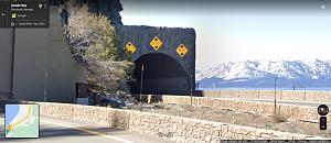
It didn't make sense to me either. The RV Life Trip Wizard app showed this warning symbol for clearance under 10 ft.

I perhaps foolishly chose to drive that route today and was nervous when I got to the tunnel. It was 2-lanes with an arched top. The peak was labeled 17' but the sides were indeed labeled 9'+. So I think the app provided a good warning. If traffic had allowed, I would have driven through the center. As it was, we cleared but I was less than comfortable.
We wanted to be close to the lake with electricity so we ended up in Zephyr Cove RV Resort. It's expensive but the location is great and the facility good enough so far. We stayed in Springville UT and then Winnemucca on the way. We plan to stay 2 or 3 nights here before continuing to the coast.
Thanks to all for the help.
|
|
|
|
|
05-17-2022, 08:00 AM
|
#9
|
|
Senior Member
Join Date: Jun 2020
Location: Salt Lake City, Utah
Trailer: 2021 Escape E5.0; 2021 F150 PowerBoost
Posts: 1,192
|
Thank you for sharing that! We do not often look for RV trip wizard and will most likely have missed that height warning. We will look for alternate routing when traveling from Mount Rose campground to South Lake Tahoe.
|
|
|
|
|
05-17-2022, 08:31 AM
|
#10
|
|
Junior Member
Join Date: Jul 2020
Location: Tahoe, California
Trailer: 2020 17b, 2020 Ford Ranger XLT
Posts: 16
|
kavm, you could take a different route, but you'd miss some good views along the way. See this article for a better idea.
Hwy 431 to Mt Rose CG is twisty east of the summit and nice down to the lake. I believe there is road construction on it this summer. There are some nice hikes in that area.
|
|
|
|
|
05-17-2022, 09:54 AM
|
#11
|
|
Senior Member
Join Date: Jul 2015
Location: Mike in Puget Sound, Washington
Trailer: Escape 21 & Jeep GC 5.7 (Previous 2012 Casita FD17 & 2010 Audi Q5)
Posts: 236
|
Quote:
|
It didn't make sense to me either. The RV Life Trip Wizard app showed this warning symbol for clearance under 10 ft.
|
Under 10' means 9'11" at one edge in this case!
Quote:
|
Escape 5.0 Specifications ; Exterior Length, 21' 2" (add 6" for spare tire) ; Max. Exterior Height, 10' Top of TV Antenna (9' 7" Top of AC) ; Exterior Width, 7' 4".
|
All these "enhanced features" in our electronics, and perhaps even travel guides in general, can be a mixed bag.
I picked up a Garmin RV 780 GPS a few years ago and although I really like Garmin's GPS units, to date the "RV" features have not provided me with any significant enhancement to my driving experience.
I also noticed that it has "erased" all of the local roadways branching off the main highway in rural areas. As an example, it did this while I drove along the highway through the Lassen National Forest.
So, I had no sense for what might be an interesting side trip without pulling out the paper maps. A Garmin forum confirmed that this is a "feature" that can't be overridden in the settings. I was disappointed as one of the things we really like to do is to wander the side roads as we travel through different areas.
__________________
You must learn from other peoples mistakes. You cant possibly live long enough to make them all yourself. - Sam Levenson
|
|
|
|
|
05-17-2022, 10:59 AM
|
#12
|
|
Site Team
Join Date: Dec 2017
Location: Mid Left Coast, California
Trailer: 2014 Escape 21
Posts: 5,152
|
FWIW, that same tunnel, the northbound side says (right to left), 14'4", 21'0", 13'7"
so its really only the southbound side, the right lane is 9'11", and thats only if you hug the outside line. If I was remotely worried, I'd hit my emergency blinkers and drive down the middle of the tunnel. Its only 250 feet end to end.
the alternative is to go up US50 and down US395, 88.
|
|
|
|
|
05-17-2022, 12:27 PM
|
#13
|
|
Senior Member
Join Date: Apr 2021
Location: Centennial, Colorado
Trailer: 2020 5.0 TA
Posts: 213
|
All good input, thank you!
My conclusion is if I see a height warning, find out what it is before going there as it MAY be real.... or not.
Next question:
Is Hwy 128 a reasonable way to go to the coast? We want to drive through Placerville and figure this road might get us a look at more than we'd see from the Gmaps recommended routes along bigger highways.
Assuming that is the route we follow, any recommendations for a place to stop one night along the way?
|
|
|
|
|
05-19-2022, 12:51 AM
|
#14
|
|
Senior Member
Join Date: Apr 2021
Location: Centennial, Colorado
Trailer: 2020 5.0 TA
Posts: 213
|
We came through Placerville as planned. We had multiple stops along Hwy 50 for cleanup that continues after the big fire. Was truly a massive area and sad to see.
After Sacramento, we decided to get off the highway and went west out of Davis on 128, then 121 to Napa. It was quite a drive- very slow, steep grades, and a lot of twisty curves. I wouldn't do it again but it was interesting and really scenic.
We were surprised to see the damage from another big fire around Lake Berryessa.
We ended up at a nice KOA in Petaluma for the night but it was a longer day than we expected.
|
|
|
|
|
05-19-2022, 01:10 AM
|
#15
|
|
Site Team
Join Date: Dec 2017
Location: Mid Left Coast, California
Trailer: 2014 Escape 21
Posts: 5,152
|
I've been driving those twisty mountain highways my whole life, I forget how they must be for someone from flatter country.
Petaluma is just north of my birthplace, Marin. Gorgeous country, great wineries and breweries abound.
|
|
|
|
|
05-19-2022, 01:12 AM
|
#16
|
|
Senior Member
Join Date: Oct 2008
Location: North Vancouver, British Columbia
Trailer: 2009 Escape 17B 2020 Toyota Highlander XLE
Posts: 17,136
|
Quote:
Originally Posted by John in Santa Cruz
I've been driving those twisty mountain highways my whole life, I forget how they must be for someone from flatter country.
|
I live in fear of falling asleep driving a straight line across the prairie.
__________________
What happens to the hole when the cheese is gone?
- Bertolt Brecht
|
|
|
|
|
05-19-2022, 08:07 AM
|
#17
|
|
Senior Member
Join Date: May 2020
Location: Overbrook, Kansas
Trailer: 2021 E19 (Padawan)
Posts: 1,964
|
Quote:
Originally Posted by gbaglo
I live in fear of falling asleep driving a straight line across the prairie.
|
Its possible, but my wife loves driving there and hates mountain driving. I dont drive much due to my eyesight, but have to plan trips to keep my wife happy. We usually leave the trailer somewhere and day trip, but even then I have to be careful with the roads I pick.
__________________
Randy & Barb
1998 C 2500 (Cruncher) and 2021 Ranger (Yoda)
|

|
|
|
05-19-2022, 08:53 AM
|
#18
|
|
Senior Member
Join Date: Jun 2020
Location: Salt Lake City, Utah
Trailer: 2021 Escape E5.0; 2021 F150 PowerBoost
Posts: 1,192
|
Quote:
Originally Posted by saguarocat
kavm, you could take a different route, but you'd miss some good views along the way. See this article for a better idea.
Hwy 431 to Mt Rose CG is twisty east of the summit and nice down to the lake. I believe there is road construction on it this summer. There are some nice hikes in that area. |
Thank you so much! Hiking it indeed our main interest/activity on our trips. Hoping to go up to Mount Rose as well but slightly concerned about heat levels in early July.
Reading the rest of the discussion, seems like the lowest point is 911. Since our 5.0 is lower than that by 3-4 inches (based upon ETI data), I am tempted to take that route (50) to South Lake Tahoe from Mount Rose CG. Seems like the feedback suggests it might be OK.
|
|
|
|
|
05-19-2022, 08:58 AM
|
#19
|
|
Senior Member
Join Date: Jun 2020
Location: Salt Lake City, Utah
Trailer: 2021 Escape E5.0; 2021 F150 PowerBoost
Posts: 1,192
|
Quote:
Originally Posted by gbaglo
I live in fear of falling asleep driving a straight line across the prairie.
|
I know this was tongue-in-cheek repartee but more seriously - this is one area we are pleased with the tech in our 2021 F150. It has a lane centering feature which provides active assist to keep the truck centered in the lane. It has been a life saver when we were new to truck and camper. Anyway, as a part of that functionality, it has an active monitoring to keep the driver focused and providing steering input. It sounds annoying, and it was initially, but it is easy to keep the driver monitoring happy. The positive is that it serves as a good way to prevent / reduce falling asleep / inattentive while driving scenarios or at least reduce the duration of such events.
|
|
|
|
|
05-19-2022, 10:59 AM
|
#20
|
|
Senior Member
Join Date: Apr 2021
Location: Centennial, Colorado
Trailer: 2020 5.0 TA
Posts: 213
|
Quote:
Originally Posted by kavm
...
Reading the rest of the discussion, seems like the lowest point is 911. Since our 5.0 is lower than that by 3-4 inches (based upon ETI data), I am tempted to take that route (50) to South Lake Tahoe from Mount Rose CG. Seems like the feedback suggests it might be OK.
|
Our 5.0 has no lift but does have the TV antenna. We drove through the tunnel in the right lane without issue. It was a judgment call but when I saw the geometry and watched trucks ahead of us, I was not too concerned. The bigger issue was the traffic. Slowing down could have been dangerous and driving down the middle was not an option.
Quote:
Originally Posted by John in Santa Cruz
I've been driving those twisty mountain highways my whole life, I forget how they must be for someone from flatter country.
Petaluma is just north of my birthplace, Marin. Gorgeous country, great wineries and breweries abound.
|
Yes it is pretty!
The road we took to Napa (121) was quite challenging for me pulling the camper. It was a good road but narrow, plenty of traffic, and sharp curves. Lots of time between 15 and 25 mph. Pretty place for sure but the full-time focus on driving reduces the scenic impact for me.
We live near mountains in CO and are used to driving winding roads in a car or truck but this was another level and pulling the trailer adds some tension for me.
Quote:
Originally Posted by kavm
I know this was tongue-in-cheek repartee but more seriously - this is one area we are pleased with the tech in our 2021 F150. It has a lane centering feature which provides active assist to keep the truck centered in the lane. It has been a life saver when we were new to truck and camper. Anyway, as a part of that functionality, it has an active monitoring to keep the driver focused and providing steering input. It sounds annoying, and it was initially, but it is easy to keep the driver monitoring happy. The positive is that it serves as a good way to prevent / reduce falling asleep / inattentive while driving scenarios or at least reduce the duration of such events.
|
This sounds like a great feature. I find the lanes here in CA are narrower than I'm used to and I'm still a novice tow driver.
|
|
|
|
|
|
| Thread Tools |
|
|
| Display Modes |
 Linear Mode Linear Mode
|
 Posting Rules
|
You may not post new threads
You may not post replies
You may not post attachments
You may not edit your posts
HTML code is Off
|
|
|
|
 » Recent Discussions
 |
|
|
|
|
|
|
|
|
|
|
|
|
|
|
|
|
|
|
|
|
|
|
|
|
|
|
|
|
|
|

|